Oct. 30, 2013
Rice Rivers Center research buoy to contribute to Chesapeake Bay system
Share this story
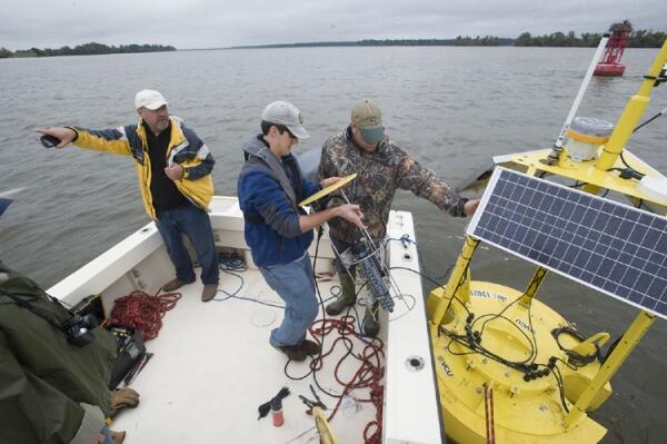
The VCU Rice Rivers Center this month deployed a 450-pound, 9-foot-tall “smart buoy” that will contribute data to the National Oceanic and Atmospheric Administration’s Chesapeake Bay Interpretive Buoy System (CBIBS) and the Mid-Atlantic Regional Coastal Ocean Observing System (MARACOOS).
The Rice Rivers Center’s research buoy is the first contributor to CBIBS to be purchased and deployed by a university partner.
According to its website, CBIBS “supports the use and management of a healthy Chesapeake Bay by providing the data and information needed to improve safety, enhance the economy and protect the environment.”
The Rice Rivers Center’s buoy, positioned about one kilometer off shore from Rice in the James River, will relay data to researchers, educators and the public via the CBIBS and MARACOOS websites in real time about the wind, weather and water quality in the area.
The buoy also features acoustic telemetry technology that allows researchers to track fish movement in real time. The technology, enabled by acoustic transmitters placed in fish, will provide a better understanding of migration and spawning behaviors in Atlantic sturgeon, striped bass and other species.
Rice Rivers Center research director Greg Garman, Ph.D., led the buoy deployment team on a cold, wet and windy October afternoon.
The soggy 10-hour day he and his team put in deconstructing, transporting, reconstructing, launching and anchoring the buoy was a long time in the making.
The idea to host a research buoy at the Rice Rivers Center was first presented to Garman and Thomas Huff, Ph.D., VCU’s vice provost for life sciences and research, about six years ago when CBIBS was in its infancy.
“And we had been talking about it for some time until we were approached again two years ago by NOAA, who wanted to set up the James River as a national pilot,” Garman said.
Officials at NOAA were interested in putting a concentration of data assets in one river because its buoys to that point were relatively scattered throughout the Chesapeake and its tributaries.
“They wanted to have a continuum from the bay up through the tidal reach of a single river,” Garman said. “Ours is now the second buoy in the James and third in close proximity.”
Instrumental in helping make the Rice Rivers Center buoy a reality, the NOAA Chesapeake Bay Office provided technical support to Garman and his team in buoy deployment and will continue that role in long-term data collection.
"NOAA is excited about the launch of the VCU buoy and the real-time monitoring data that will come from it," said Peyton Robertson, director of the NOAA Chesapeake Bay Office. "As a result of the VCU-NOAA partnership, the data from this buoy will be integrated into the NOAA Chesapeake Bay Interpretive Buoy System, thereby providing essential information for scientists and decision-makers about the James River, the bay and the living resources that depend on them."
Doug Wilson, who is a consultant with the NOAA Chesapeake Bay Office and the director of MARACOOS Chesapeake Bay, was on board and braved the elements with Garman on deployment day.
He said the James River is important in studying the Chesapeake Bay both because of its living resources, such as the Atlantic sturgeon, and because of opportunities to study water quality, turbidity and dissolved oxygen in the third largest contributor of fresh water to the bay.
“The James is more urbanized and more influenced by human activity than many of the other tributaries,” Garman said. “Also, the river’s position at the bottom of the bay allows us to study whether that water flows into the bay or the ocean.”
Being on the James in general is not the Rice Rivers Center’s only location-based research advantage, so too is its distance upriver – about 100 miles from the Chesapeake Bay.
“We’re in an interesting place on a tidal river,” Garman said. “It’s a location that is the mixing point – the interface – between waters and landscapes dominated more by the Chesapeake Bay or the ocean and waters and landscapes dominated more by the watershed of the James River. Depending on the tide, we might have more marine-dominated water or more inland-influenced water.
“This unique location affects everything from the animal life to water chemistry and water pollution.”
In realizing these research prospects, Garman said he couldn’t pass up the opportunity to connect the Rice Center to CBIBS and MARACOOS, so he took it upon his team at the center to do as much as possible to support VCU Life Sciences’ decision to purchase the first university-financed buoy.
This is an important step, Wilson said, as he would like to see regional expansion of CBIBS and MARACOOS .
“If there is going to be expansion it’s going to be by developing these partnership opportunities,” he said.
“It was a pilot, and now it’s a model,” Garman said. “If NOAA wants to expand their system, they can point to us and say, ‘This is how VCU did it.’”
Subscribe for free to the weekly VCU News email newsletter at http://newsletter.news.vcu.
Subscribe to VCU News
Subscribe to VCU News at newsletter.vcu.edu and receive a selection of stories, videos, photos, news clips and event listings in your inbox.